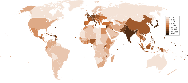
फाइल:Countries by population density.svg

पूर्वावलोकन PNG का आकार SVG फ़ाइल: ८०० × ३५३ पिक्सेल अउर resolutions: ३२० × १४१ पिक्सेल | ६४० × २८२ पिक्सेल | १,०२४ × ४५२ पिक्सेल | १,२८० × ५६५ पिक्सेल | २,५६० × १,१२९ पिक्सेल | ६,००० × २,६४७ पिक्सेल।
मूल फ़ाइल (SVG फ़ाईल, साधारणत: ६,००० × २,६४७ पीक्सेल्स, फ़ाईल कय आकार: १.६२ एमबी)
फाइल कय इतिहास
मिति/समय मे क्लिक कइकै फाइल उ समय कैसन बिलगात रहा देखा जाय
| तारीख/समय | अंगूठाकार प्रारूप | आकार | सदस्य | टिप्पणी | |
|---|---|---|---|---|---|
| अबहिनै कय | ०५:०३, २२ दिसम्बर २०११ |  | ६,००० × २,६४७ (१.६२ एमबी) | Quibik | added transparency |
| १९:१३, २० फरवरी २०११ |  | ६,००० × २,६४७ (१.६२ एमबी) | Erik del Toro Streb | typographically corrected | |
| ०७:५२, ७ जनवरी २००८ |  | ६,००० × २,६४७ (१.६२ एमबी) | Briefplan~commonswiki | {{Information |Description=A map of the world, with colours to highlight the population density of each country or territory. Numbers on the legend are in people per km<sup>2</sup>, and all countries smaller than 20,000 km<sup>2</sup> are represented by a |
फ़ाइल कय उपयोग
निचे दिहा पन्ना में इ फ़ाइल कय कड़ि हैं:
वैश्विक फाइल प्रयोग
अउर विकि जवन इ फाइल कय प्रयोग करत हँय:
- af.wikipedia.org पर उपयोग
- ar.wikipedia.org पर उपयोग
- arz.wikipedia.org पर उपयोग
- ast.wikipedia.org पर उपयोग
- av.wikipedia.org पर उपयोग
- azb.wikipedia.org पर उपयोग
- az.wikipedia.org पर उपयोग
- ba.wikipedia.org पर उपयोग
- be.wikipedia.org पर उपयोग
- bg.wikipedia.org पर उपयोग
- bs.wikipedia.org पर उपयोग
- ca.wikipedia.org पर उपयोग
- ckb.wikipedia.org पर उपयोग
- cs.wikipedia.org पर उपयोग
- cy.wikipedia.org पर उपयोग
- de.wikipedia.org पर उपयोग
- de.wikiversity.org पर उपयोग
- diq.wikipedia.org पर उपयोग
- dsb.wikipedia.org पर उपयोग
- en.wikipedia.org पर उपयोग
- eo.wikipedia.org पर उपयोग
- es.wikipedia.org पर उपयोग
- eu.wikipedia.org पर उपयोग
- fi.wikipedia.org पर उपयोग
- fr.wikipedia.org पर उपयोग
- gl.wikipedia.org पर उपयोग
इ फ़ाइल कय वैश्विक उपयोग कय अधिक जानकारी देखा जाय।